
Just the design plans for Phase I of what could be a two-year construction project will cost a cool $1-million; Oxford taxpayers are on the hook for exactly $0.00.
At a Special Town Council meeting called for Thursday evening, councillors gave staff the go-ahead to finalize a contract with DesignPoint Engineering & Surveying and get the ball rolling on the “Across the Highway” expansion of water & sewer services.
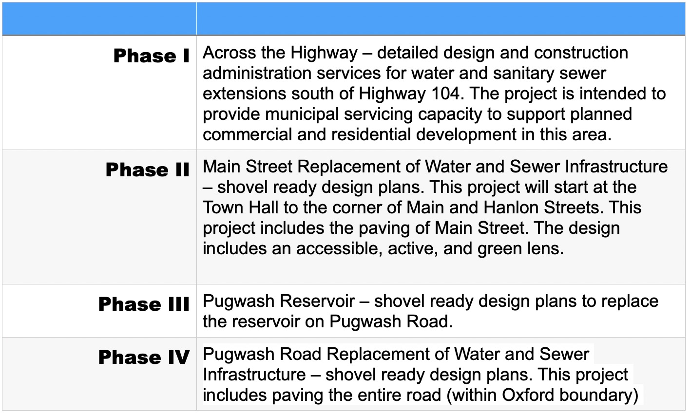
This is Phase I of the Town’s four-phase “Service Renewal to Support Community Growth” (SRSCG) that will see services extended across the 104 Highway; Main St. infrastructure (below and above ground) completely rebuilt between Town Hall and MacDiarmid’s Funeral Home; a new water line and paving of Pugwash Road; and a new water reservoir to replace the original water storage system on Pugwash Road.
[See our previous coverage: “Dollars to Potholes: The Province Funds Oxford Infrastructure“]
In the agenda package prepared for the meeting, we learned that 50% of the funding for the design plans is coming from the provincial Growth and Renewal for Infrastructure Development Program (GRID), while the remaining 50% is being covered by the developer of the lands on the southern limits of the municipality, on the other side of the 104 Highway connector. Town of Oxford capital funds are not required at this stage, though they will be drawn upon once shovels hit the ground.
As to what will be built on those properties, we have only speculation at this point. The rezoning allows for commercial and residential development, but nothing specific has been identified. Oxford CAO Linda Cloney says the expansion of the town’s water and sewer infrastructure to that area of the municipality will lead to development that will in any scenario add to the tax base upon which the town relies to pay for municipal services.
The four phases of the SRSCG are estimated to cost a cool $14.2-million, cost-shared between the Town and government “50-cent dollar” grants. Oxford’s capital reserve account has been building up over the past few years to an amount that meets the threshold to qualify for that support.
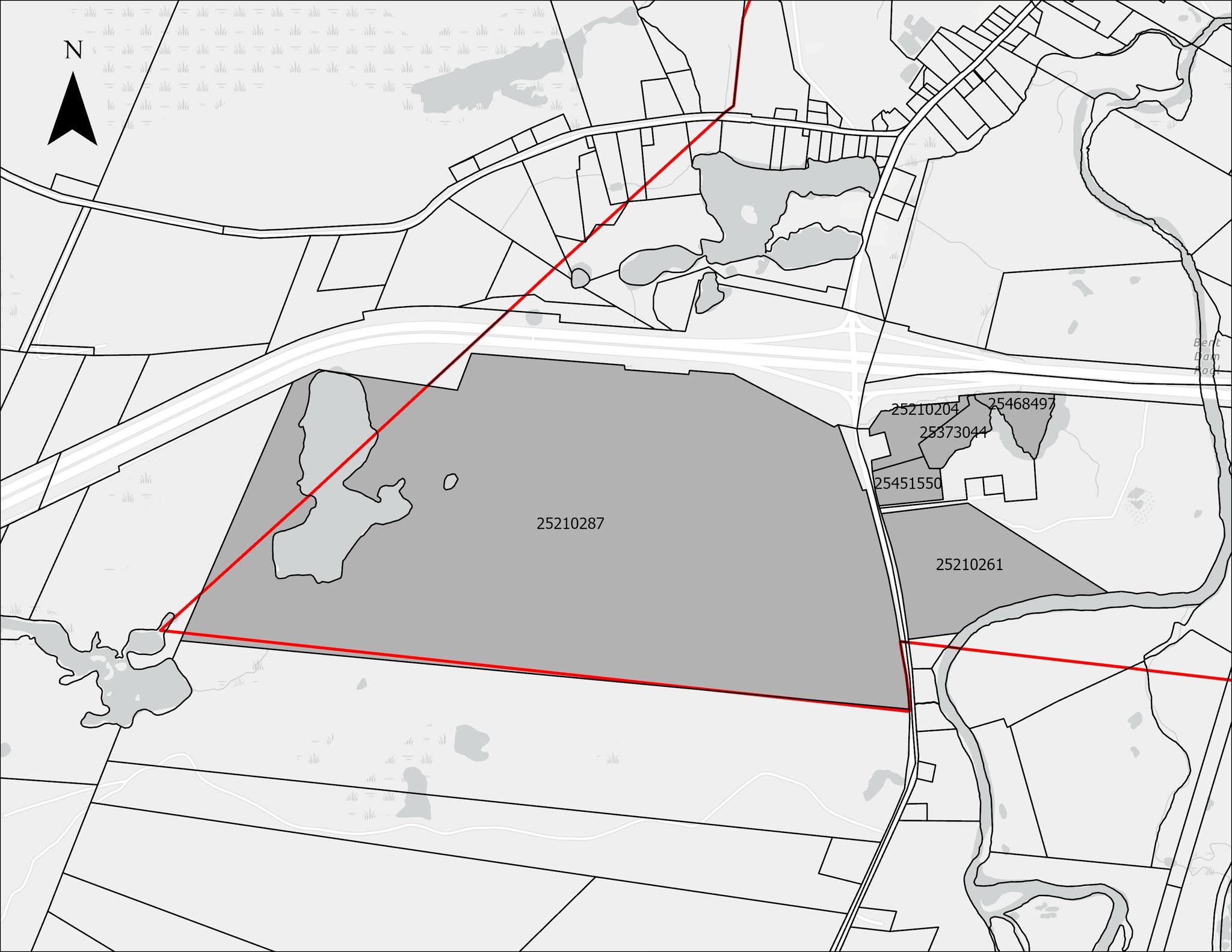
The area to be serviced stretches from the Highway 104 connector down Highway 321 to the town limits, and westward to include a portion of Vickery Lake. The eastern side of Highway 321 is also included in the project. The affected properties were rezoned in 2025 from Rural Development land to Main Street Mixed-Use Zone land to allow for future commercial and residential development.
With the selection of DesignPoint Engineering & Surveying, this massive infrastructure project begins to lumber its way toward reality. It is expected that the “shovel-ready” plans will be completed and approved by January, 2027, at which point the tender will be issued for the actual construction work. This is much earlier than previous infrastructure tenders have typically gone out, as the town hopes to quickly identify the company and see the work begin as early in the new year as possible.
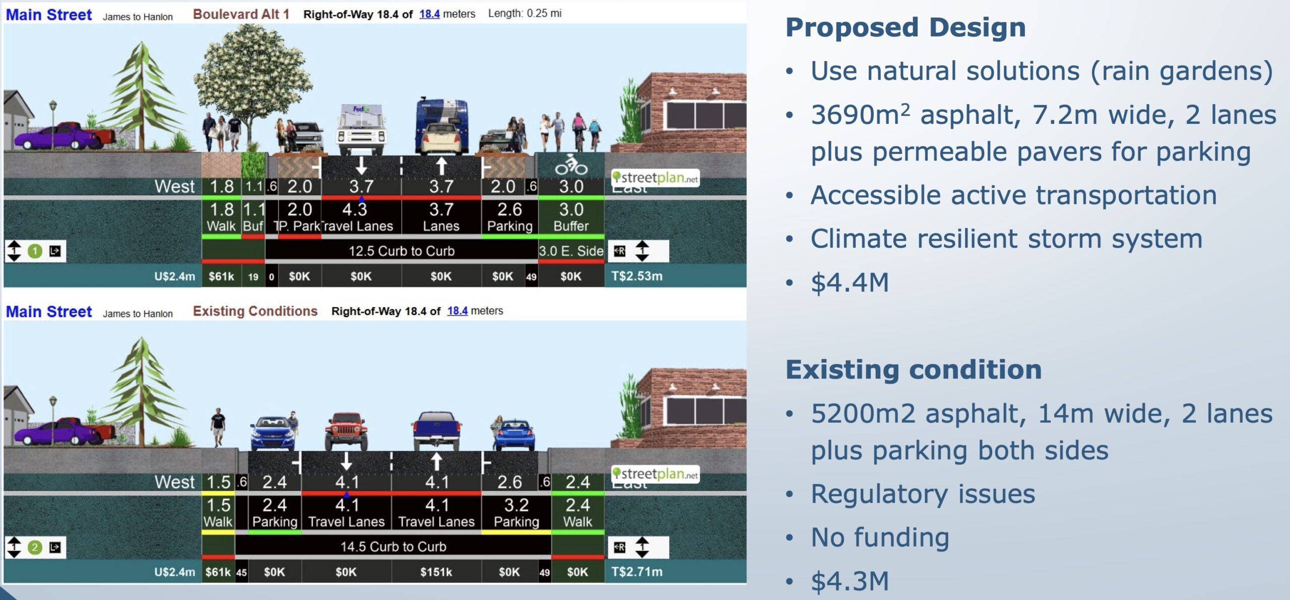
The tender for design plans for Phase II — what is essentially the gutting of Main St. from Water St. up to Hanlon St. — should be issued soon, following similar timelines to the Phase I competition, also with the goal of having that part of the project completed by the Fall of next year. Significant funding for that part of the infrastructure renewal is coming from the Local Leadership for Climate Adaptation (LLCA) fund, and will radically change the appearance of that section of Main St. while completely replacing the underground services.
Given the capital reserves available, and the cycle of government matching funds applications, it is expected (though not confirmed) that the Pugwash Road reservoir project and the Pugwash Road water line & paving (Phase III & IV) will be pushed to 2028.
After years of Oxford residents complaining about the condition of the main thoroughfare, this is a positive indication that things are soon to improve. But before it gets better, residents will have to deal with the inconveniences of construction on a scale this town hasn’t seen perhaps in its history, affecting traffic in the downtown core.
And once that’s done? The Asset Management Mapping project undertaken by the town a couple of years ago showed that almost all secondary streets in town are in need of water line replacement (with sewer and stormwater in somewhat better condition), with a high probability of some service interruption in the near future. Town Staff continue to plan for the capital reserve needs to address those future projects, an effort that balances tax revenues with the cyclical nature of government funding programmes and protecting core services.

